Archaeological Science Today: From Dating Timelines to Reading Soils, Diets, and Distant Landscapes
Beneath every trowel mark lies a puzzle of time, place, and human experience. Today that puzzle is approached with microscopes, isotopes, satellite images, and statistical models working alongside careful excavation. Together they establish sequences, trace buried landscapes, reconstruct meals, and protect fragile traces of past lives from being lost.
This story is part of DailySeekers's practical reading library across everyday topics.
Building Sequences: Layers, Measurements, and Chronological Models
Reading the ground as a sequence
Sediments and fills accumulate over long periods, so depth usually corresponds to age. Archaeologists treat these layers as ordered pages, looking for differences in color, texture, inclusions, and boundaries to separate one from another. A grave cut into a particular band of soil is younger than what it slices through and older than anything clearly resting on top.
This “who sits above whom” principle supports almost every later scientific measurement. If layers are disturbed by digging, burrowing, or erosion, that disturbance is recorded and used as a warning that materials may be mixed. In many sites, powerful insights come from combining a very careful record of these physical relationships with a smaller number of well‑placed analyses.
From single ages to full timelines
Layering gives order, while laboratory techniques add calendar ranges. Organic remains such as bone or charcoal can be assessed to estimate when an organism stopped exchanging carbon with the atmosphere. Construction materials can also be tested to tie building phases to particular parts of the sequence.
Archaeologists rarely rely on a lone result. They combine many measurements with information about which samples lie above, below, or alongside each other. Statistical models help explore which sets of ages best fit the observed order of layers and any independent environmental signals.
These models do not remove uncertainty, and responsible studies present ranges rather than precise‑looking single numbers. Their strength lies in highlighting inconsistencies, isolating outliers, and sharpening questions about the pace of change. Was a settlement occupied continuously or in pulses? Did construction cluster around particular phases of environmental stress?
| Choice or scenario | When this approach is especially useful | Trade‑offs and cautions |
|---|---|---|
| Single age result | Quick check that a feature broadly fits its expected period | Limited context; can be misleading if taken as exact |
| Series of ages from one feature | Understanding duration of use or rebuilding | Requires more material and careful sampling strategy |
| Full model using many ages and layer order | Exploring detailed occupation histories and event sequences | Needs strong stratigraphic control and transparent assumptions |
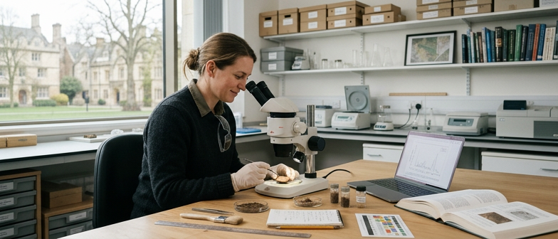
Close‑up Clues: Soils, Surfaces, and Microscopic Traces
Microscopes allow apparently unremarkable earth and surfaces to be treated as detailed records of activity. Under high magnification, a dark streak in a floor becomes compacted ash, splashed fat, or trodden plant material. Thin slices of undisturbed sediment, set in resin and examined in cross‑section, can reveal repeated cycles of burning, sweeping, repair, and dumping.
Subtle changes in the amount of ash, tiny charcoal, crushed bone, or trampled dung between nearby spots can separate cooking areas from dumping zones or passageways. This kind of work connects broad interpretations about “household routine” to close observation of tiny inclusions and micro‑layering.
Traces of use on tools and bodies
The same close‑focus mindset applies to objects. Use‑wear analysis studies microscopic scars, rounding, and polish on tool edges. The angle of a cutting edge and the pattern of scratches help distinguish implements used for scraping, cutting, or grinding. Projects that track how shape changes through use make it easier to separate tools made for different tasks, even when they look similar at first glance.
Teeth and metals also store small‑scale histories. Unusual dental wear can suggest people used their mouths in particular tasks, such as gripping or softening materials. Chemical and peptide markers from tooth samples refine those interpretations by linking wear to diet or habitual activities.
On metal objects, non‑destructive techniques can measure surface composition without taking a physical sample. Slight differences in trace elements can group items that were made in similar ways or that moved along related exchange networks. This kind of work often highlights ordinary objects and bodies as key sources of information about craft, labour, and learning.
| Type of microscopic evidence | Everyday questions it can inform | Typical limitations |
|---|---|---|
| Soil thin sections | How often fires were lit, floors renewed, or rubbish dumped | Requires intact samples and specialist lab work |
| Edge wear on tools | What tasks tools performed and how intensively they were used | Hard to separate similar activities with overlapping traces |
| Dental wear and residues | Food textures, craft habits, and life‑course changes | Needs careful comparison with modern reference samples |
Food, Movement, and Residues: Reconstructing Past Lives
Bones and teeth record aspects of diet and environment. Stable forms of common elements vary slightly between different plants, animals, and water sources. When people or animals eat and drink, those signals are incorporated into tissues. By comparing these signatures in individuals from the same burial ground, researchers can estimate who relied more heavily on animal protein, freshwater resources, or plant‑based meals.
Differences sometimes line up with other aspects of burial practice, hinting at social roles or access to particular foods. Because teeth form in childhood and then stop changing, their signals relate to early life. Bones, which remodel more slowly, reflect later years. Mismatches between the two can suggest movement between regions, changes in livelihood, or shifts from one kind of diet to another.
Microscopic wear patterns, trapped food particles, and small mineralized deposits on teeth add extra detail. In some cases, these tiny remains point to a varied menu that included meat, fish, shellfish, seeds, plants, and fungi.
Archaeological science extends beyond humans. The same measurements applied to animal remains can reveal whether flocks were pasture‑fed near fields or ranged in wilder areas, adding depth to studies of farming, hunting, and exchange. Marine mammals and fish can record feeding grounds and changes in water conditions over long periods.
Pottery and other containers act as another archive. Fats from meat, milk, or marine oils can seep into porous walls and survive as altered molecules. With modern chemical profiling, it is often possible to distinguish dairy from carcass fats or to separate aquatic from terrestrial sources. A simple sherd can therefore carry evidence of stews, storage practices, seasonal feasts, or everyday cooking routines, linking vessel shapes to specific roles in food preparation and consumption.
Seeing the Invisible: Aerial Views, Sensors, and Pattern Recognition
Reading buried structures from above
From ground level, many ancient sites blend into fields or forest. From above, small variations in colour, vegetation growth, or surface topography can outline buried walls, ditches, roads, and entire settlements. Satellite images, aerial photographs, and other remote‑sensing tools convert these faint traces into legible patterns.
Different sensors capture different aspects of the landscape. Optical images reveal crop marks, soil marks, and shadows. Elevation data, organised into digital models, highlights ridges, terraces, embankments, and platforms. Because they cover wide areas, these datasets are valuable where ground access is limited or surfaces have been heavily altered.
Archaeologists scan these layers on screen, mark shapes that resemble enclosures, trackways, or building plots, and then plan targeted surveys or test excavations. This approach can reduce unnecessary disturbance while still identifying key areas for detailed investigation.
From dense imagery to meaningful patterns
The main challenge is volume. A single region may be represented by many overlapping image sets and elevation grids collected in different conditions. Manually inspecting each file is rarely practical.
Pattern‑detection tools help manage this overload. Algorithms can flag regular geometries—circles, rectangles, straight alignments—that might indicate structures or boundaries. They can also highlight unusual textures that stand out from natural background variation.
Airborne laser scanning adds a further layer, especially under tree cover. By effectively filtering out vegetation in the data, low earthen features such as canals, terraces, and small platforms become visible. Once promising features are identified remotely, teams return to the ground with clearer questions: Are these natural ridges or engineered banks? Do subtle depressions mark ancient routes or more recent tracks?
Remote sensing does not replace excavation or local knowledge, but it reshapes how projects are designed. Researchers work across scales, linking broad landscape patterns to specific finds and micro‑scale analyses in the lab. In doing so, they show how many different strands of evidence—layers, molecules, scratches, and pixels—can be woven together to build careful, testable stories about past lives.
Q&A
-
How do archaeological science methods change the way excavations are planned today?
Archaeological science methods push projects to start with clear sampling strategies, integrating dating techniques, soil and artifact analysis, and remote sensing tools from the outset. Instead of digging large areas blindly, teams design smaller, well‑documented interventions whose finds can feed chronological models, preservation science assessments, and broader interdisciplinary research questions. -
What is the practical value of a dating techniques overview for non‑specialist archaeologists?
A concise dating techniques overview helps field archaeologists choose appropriate methods, estimate needed sample sizes, and avoid common contamination pitfalls. Understanding strengths and limits of radiocarbon, luminescence, and other approaches supports realistic expectations, better budgeting, and more persuasive interpretations when timelines are combined with environmental and cultural datasets. -
How does soil and artifact analysis contribute to reconstructing ancient diet evidence?
Soil and artifact analysis recovers microscopic plant remains, burnt residues, and absorbed lipids that complement bones and teeth. These traces can distinguish cooking zones, waste areas, and food‑processing spots, while chemical signatures in pottery or grinding stones refine reconstructions of ancient diet evidence, including seasonality and food sharing patterns within households or communities. -
In what ways do remote sensing tools interact with preservation science basics?
Remote sensing tools identify buried features without disturbing fragile deposits, aligning closely with preservation science basics that prioritize minimal intervention. By mapping threats like erosion, looting scars, or encroaching development, these datasets support risk assessments, targeted protective measures, and long‑term monitoring strategies that balance research access with heritage conservation needs. -
Why is interdisciplinary research essential for interpreting complex archaeological science datasets?
Interdisciplinary research brings together geochemists, statisticians, ecologists, and conservators to interpret diverse evidence streams. Their combined expertise links dating curves, isotopic signals, soil processes, and material decay pathways. This collaboration reduces misinterpretation, encourages transparent modelling choices, and produces more nuanced narratives about past economies, mobility, diets, and landscape transformations.